
Global change in drylands of the Western U.S.
Forests in the western U.S. are subject to increasing wildfires, drought, and land use that is fundamentally altering their utility as natural climate solutions. We used time series of remote sensing data create annual time series datasets (1985-2021) of vegetation cover and disturbance in California, finding fire-driven net declines in tree cover from 1985 to 2021 across California. The nature of fire is changing, and its increasing severity and targeting of dense forests is amplifying tree cover losses in California.
In a NASA Land Cover and Land Use Change project, we are combining airborne imagery with time series of satellite thermal data, deep learning, and imaging spectroscopy to improve maps of forest mortality occurring due to drought and insect attack. These maps will provide essential information on sensitivity of western U.S. forests to rapid climate change.
In a NASA Early Career Investigators project, we are characterizing changes in aboveground biomass due to woody plant encroachment and climate change in sparse woodlands and shrublands across the western U.S.! This will leverage NEON airborne lidar data and machine learning to characterize this global change impact.
Selected relevant publications:
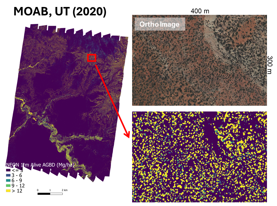
Aboveground biomass density of individual shrubs and trees in MOAB, UT. Data is derived from airborne lidar, field data, and allometries.

California fires in 1985-1995 affected typically warmer and drier areas, while more recent fires in 2011-2021 have begun to affect typically cooler, wetter areas, where older, denser forests exist

Woody plant encroachment evident in Stansbury Mountains of Utah. Left: photo from 1901. Right: photo from 1977. Credit Garry Rogers